Brisbane Aerial Photography
Brisbane Aerial Photography is conducted from our aviation base at Archerfield Airport. A large portion of our Brisbane aerial photography assignments are around the Greater Brisbane. These operations can be challenging at times due to the proximity to Brisbane Airport and Airspace restrictions. As we are very experienced the job is always completed and that Hero Shot is captured. We are not just aerial photographers and offer a variety of photography services to meet our clients needs
Our services for Brisbane include;
- Brisbane Aerial Photography
- Brisbane Commercial Photography
- Brisbane Architectural Photography
- Brisbane Construction Photography
- Brisbane Elevated (Mast) Photography
- Brisbane Drone Photography
- Brisbane Drone Survey
- Brisbane Drone Asset Inspection
- Brisbane Drone Courses
Flying in Brisbane Airspace – Brisbane Aerial Photography
Conducting Brisbane aerial photography asignments can be challeging as most of the Greater Brisbane suburbs are in airspace that is classed as Controlled Airspance and is under the control Brisbane Air Traffic Control. Obvioulsy passenger jets have priority over smaller aerial photography aircrafts.
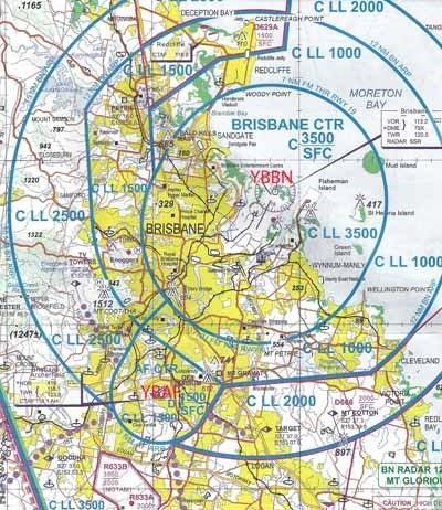
The below Brisbane Aviation Map, a VTC, shows the Brisbane airspace. The Blue circles represent areas controlled by Brisbane Air Traffic Control at varying heights. I have marked the map with YBBN which is the code for Brisbane airport and YBAF which is the code for Archerfield Airport so you can see their location.
Brisbane Aerial Photography Image Library
Aerial Hotshots has a image library that contains a selection of ‘working’ Brisbane aerial photography images captured to meet sales, marketing and advertising campaigns and as such are ideal for real estate agents, land developers, construction companies and the like. Click on this link to view some Brisbane Aerial Photography examples from our image library.
Brisbane – General Information
Brisbane Urban structure – Great for Brisbane Aerial Photography
The Brisbane central business district (CBD) lies in a curve of the Brisbane river. The CBD covers 2.2 km2 (0.8 sq mi) and is walkable. Central streets are named after members of the rotal famaily, Queen street is Brisbane’s traditional main street. Streets named after female members (Adelaide, Alice, Ann, Charlotte, Elizabeth, Margaret, Mary) run parallel to Queen street and Queen street Mall (named in honour of Queen Victoria) and perpendicular to streets named after male members (Albert, Edward, George, William). The city has retained some heritage buildings dating back to 1820s. The Old Windmill, in Wickham Park, built by convict labour in 1824,is the oldest surviving building in Brisbane. The Old Windmill was originally used for the grinding of grain and a punishment for the convicts who manually operated the grinding mill. The Old Windmill tower’s other significant claim to fame, largely ignored, is that the first television signals in the southern hemisphere were transmitted from it by experimenters in April 1934 – long before TV commenced in most places. These experimental TV broadcasts continued until World War II.The Old Commissariat Store, on William Street, built by convict labour in 1828, was originally used partly as a grainhouse, has also been a hostel for immigrants and used for the storage of records. Built with Brisbane tuff from the nearby Kangaroo Point Cliffs and sandstone from a quarry near today’s Albion Park Racecourse, it is now the home of the Royal Historical Society of Brisbane. It contains a museum and can also be hired for small functions. The city has a density of 379.4 people per square kilometre, which is high for an Australian city and comparable to that of Sydney. However like many western cities, Brisbane sprawls into the greater metropolitan area. This results from the fact that most of Brisbane’s housing stock consists of detached houses.
Early legislation decreed a minimum size for residential blocks resulting in few terrace housesbeing constructed in Brisbane. Recently the density of the city and inner city neighbourhoods has increased with the construction of apartments, with the result that the population of the central business district has doubled over the last 5 years.The high density housing that historically existed came in the form of miniature Queenslander-style houses which resemble the much larger traditional styles but are sometimes only one quarter the size. These miniature Queenslanders are becoming scarce but can still be seen in the inner city suburbs. Multi residence accommodations (such as apartment blocks) are relatively new to Brisbane, with few such blocks built before 1970, other than in inner suburbs such as New Farm. Pre-1950 housing was often built in a distinctive architectural style known as a Queenslander, featuring timber construction with large verandes and high ceilings. The relatively low cost of timber in South-East Queensland meant that until recently most residences were constructed of timber, rather than brick or stone. Many of these houses are elevated on stumps (also called “stilts”), that were originally timber, but are now frequently replaced by steel or concrete. Brisbane is home to several of Australias tallest buildings. Brisbane’s tallest buildings are Soleil at 243 metres, Auroa Tower at 207 metres, Riparian Plaza at 200 metres, One One One Eagle street at 195 metres, and Infinity, at 262 metres, which is currently under construction
Brisbane Climate – Great for Brisbane Aerial Photography
Brisbane has a humid subtropical climate with warm to hot and humid summers and dry, moderately warm winters. From November to March, thunderstorms are common over Brisbane, with the more severe events accompanied by large damaging hail stones, torrential rain and destructive winds.
The city’s highest recorded temperature was 43.2 °C (110 °F) on 26 January 1940. On 19 July 2007, Brisbane’s temperature fell below the freezing point for the first time since records began, registering −0.1 °C (31.8 °F) at the airport.In 2009 Brisbane recorded its hottest winter day at 35.4 °C (95.7 °F) on 24 August.Brisbane’s wettest day occurred on 21 January 1887, when 465 millimetres (18.3 in) of rain fell on the city, the highest maximum daily rainfall of Australia’s capital cities.
From 2001 until 2010, Brisbane and surrounding temperate areas had been experiencing the most severe drought in over a century, with dam levels dropping to 16.9% of their capacity on 10 August 2007. Residents were mandated by local laws to observlevel 6 water restrictions on gardening and other outdoor water usage. Per capita water usage is below 140 litres per day, giving Brisbane one of the lowest per capita usages of water of any developed city in the world. On Sunday 9 January 2011, an upper low crossed north of Brisbane and dropped rainfall on an already saturated southeast coast of Queensland, resulting in severe flooding and damage in Brisbane and the surrounding area,ironically the same storm season also resulted in the water storage climbing to over 98% of maximum capacity and breaking the drought.Water restrictions have been replaced with water conservation measures that aim at a target of 200 litres per day/per person, but consumption is rarely over 160 litres. Dust storms in Brisbane are extremely rare; on 23 September 2009, however, a severe dust storm blanketed Brisbane, as well as other parts of eastern Australia.
Brisbane also lies in the Tropical Cyclone risk area. Although cyclones hitting Brisbane are rare, they have happened in the past. The last cyclone to affect Brisbane but not directly cross the city was Tropical Cyclone Hamish in March 2009, although the cyclone remained approx 350 km (220 mi) north of Brisbanebut caused significant damage to beaches and caused the worst oil spill in Moreton Bay.Average annual temperature of the sea is 24 °C (75 °F), from 21 °C (70 °F) in July to 27 °C (81 °F) in February.
In November 2011, Brisbane saw 22 days with no recorded rainfall, which is the driest start to November since 1919.
August 2012 was the city’s driest August and the driest month ever experienced in its recorded history (records at the Brisbane Airport commenced in 1929, although the station closed in February 2000).At the meteorological station in the city’s downtown core (Brisbane Station), only 0.2 mm of precipitation was recorded in August 2012.


